All businesses listed in this directory provide services to the Middle Peninsula.
- Please search by category or terms related to a company's service. -


Painter, Virginia 23420, US
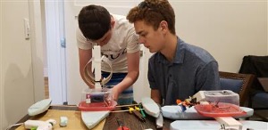
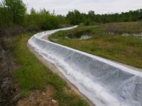
Bathymetric Maps We create maps of creeks, ponds, lakes, and other bodies of water cheaper and faster than traditional methods. These maps can be viewed digitally or printed physically. Change Monitoring Using sonar systems and high resolution 360 degree cameras above and below the water, we provide the footage you need to track the change of environmental projects, aquaculture crops, and other areas of interest. Marine Infrastructure Inspection Our hydro drones provide video footage of bridges, piers, docks, and other infrastructure safer, faster, and from perspectives unattainable by other methods. Education We teach STEM classes on hydro drone operation, environmental monitoring, engineering methods and practices, geodesy, and surveying .
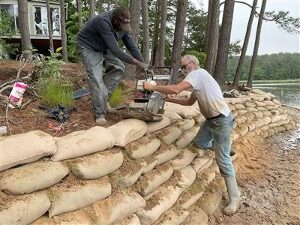
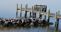
Additional services includes full documentation of construction project contruction stages and ongoing updates on project conditions such as living shorelines.
Data acquisition for project planning and permitting Documentation of project construction phases Bathymetric mapping for project design, dredging, channel location Environmental change monitoring Marine infrastructure inspection Education.


Williamsburg, Virginia 23188, US

Norfolk, Virginia 23508, US

Tampa, Florida 33629, US

Chesapeake, Virginia 23320, US

Commerce, Georgia 30529, US

Grand Rapids, Michigan 49512, US

Suffolk, Virginia 23434, US

Diggs, Virginia 23045, US

Richmond, Virginia 23225, US

Alexandria, Virginia 22314, US

Pasadena, Maryland 21122, US

Norfolk, Virginia 23513, US

Hartfield, Virginia 23071, US
New York, New York 10005, US

Deltaville, Virginia 23043, US
Hampton, Virginia 23666, US
Virginia Beach, Virginia 23452, US

Berne, Indiana 46711, US

Houma, Louisiana 70364, US

Norfolk, Virginia 23510, US

Frederick, Maryland 21702, US
Gloucester Point, Virginia 23072, US

Richmond, Virginia 23237, US

Williamsburg, Virginia 23185, US

Monroe, New Jersey 08094, US
Gloucester, Virginia 23061, US
Maidens, Virginia 23102, US

Wake Forest, North Carolina 27587, US

Baltimore, Maryland 21230, US

Boca Raton, Florida 33487, US

Buffalo, New York 14228, US

Richmond, Virginia 23230, US
Hagerstown, Maryland 21742, US

Chesapeake, Virginia 23322, US
Gloucester, Virginia 23061, US

Virginia Beach, Virginia 23451, US

Gloucester, Virginia 23061, US

Chesapeake, Virginia 23323, US

Virginia Beach, Virginia 23455, US

Deltaville, Virginia 23043, US

Wattsville, Virginia 23303, US 43.51 km

Diggs, Virginia 23045, US 46.44 km
Diggs, Virginia 23045, US 46.44 km
Deltaville, Virginia 23043, US 48.25 km
Deltaville, Virginia 23043, US 48.94 km
White Stone, Virginia 22578, US 50.85 km
Hartfield, Virginia 23071, US 56.44 km

Topping, Virginia 23169, US 56.79 km
Gloucester, Virginia 23061, US 65.55 km

Urbanna, Virginia 23175, US 67.13 km
Gloucester, Virginia 23061, US 67.57 km

Saluda, Virginia 23149, US 69.87 km

Gloucester Point, Virginia 23062, US 72.53 km
Gloucester Point, Virginia 23072, US 72.69 km
Gloucester, Virginia 23061, US 75.92 km
Hampton, Virginia 23666, US 78.79 km

Williamsburg, Virginia 23185, US 85.75 km

Newport News, Virginia 23606, US 85.84 km

Virginia Beach, Virginia 23455, US 86.38 km
Williamsburg, Virginia 23185, US 86.41 km
Virginia Beach, Virginia 23451, US 88.5 km
Virginia Beach, Virginia 23455, US 89.42 km
Williamsburg, Virginia 23188, US 90.63 km
Norfolk, Virginia 23513, US 90.89 km
Virginia Beach, Virginia 23452, US 91.85 km

Norfolk, Virginia 23508, US 93.77 km

Williamsburg, Virginia 23185, US 93.96 km
Norfolk, Virginia 23508, US 94.58 km
Norfolk, Virginia 23510, US 96.73 km
About Us
Submit Now
Want to help?
Download more information here about how to bring this program to your coastal community.
DOWNLOAD